
This gallery contains 24 photos.
This gallery contains 24 photos.

Seattle, WA - August 2011
Our favorites:
Do: Klondike Gold Rush National Historical Park (in Pioneer Square)
Do: Underground Tour
See: Columbia Tower (view from the 73rd floor)
Eat: Breakfast – 5 Spot
Eat: Lunch – Delicatus
Eat: Dinner – Staple & Fancy (family style supper a must!)

A few weeks ago I posted about our potential detour on Cottonwood Canyon Road. Well we arrived at the turn off on April 3rd to find a sign that read “Road temporarily closed 15 miles ahead.” A collective “Nooooooo!” rang out. We decided since we were there, we might as well check out the beginning section that was open. The dirt road was in pretty good shape, just a few jiggly washboard sections. Our rented Mitsubishi Endeavor took it like a champ. After about 8 miles, we stopped at a point overlooking the Paria River and had a look around before heading back to Highway 98 to continue on to Bryce Canyon.
Not all was lost, however. While at the Grand Staircase, Escalante National Monument entrance plaque, we snagged an area brochure and found an alternate (slightly) off-road route through the area. We turned off of Highway 98 onto Johnson Canyon Road which lead to County Road 1854 and then onto Glendale Bench Road. We merged back onto Highway 98 at the town of Glendale, Utah. While not as remote or interesting as the entire length of Cottonwood Canyon road would have been, there were some beautiful, multicolored bluffs, winding dirt surfaces and not another car in sight. Not too shabby for an on-the-fly detour.

The Endeavor at our stopping point on Cottonwood Canyon Road. Starkly beautiful.

The paved portion of Johnson Canyon Road.

Hike to Hollywood sign - April 2012
Our favorites:
Do: Getty Villa
Do: Petersen Automotive Museum
See: Griffith Observatory
Eat: Brunch – Kokomo Cafe
Eat: Dinner – Father’s Office (great beer selection)
While hiking last week, we encountered lots of people on the trails. In passing, we sometimes caught a random sentence or exchange being spoken by other hikers that made us laugh. (Side note: Bribing children with food seems to be a popular solution to family vacation problems.)
Here are a few of our favorite out of context trail quotes:
“I want a fruit rollup!” “You can have a fruit rollup if you participate.”
“Melanie, adding drama won’t help the situation.”
“You HIKE with your FEET!”
“If I WANT a banana I will EAT a banana.” (in a British accent)
“If you do that, I’ll throw you over the edge.”
“I’ll buy you an ice cream sundae if you stop bitching.”
“I can’t believe they don’t have rails here.”
“Don’t worry Grandma. I won’t let you roll down the mountain backwards.”
“And now he won’t wear any other shoes! It’s ridiculous!”
“She knows what to do, I just need to tune her.”

Angels Landing, Zion National Park - April 2012
Our favorites:
Stay: Zion Park Motel (family-owned, centrally located)
Eat: Breakfast – Mean Bean Coffee House
Do: Angels Landing Trail (5 strenuous miles, with spectacular 360 deg. views of Zion Canyon at trail end – last half-mile not for anyone with a fear of heights: trail follows narrow ridge with 1,500 ft drop on one or both sides!)
Do: Hidden Canyon Trail (strenuous 2.5 miles – continue hiking after maintained trail ends until you reach the arch in the hidden canyon)
Do: Watchman Trail (moderate 2.5 miles near Visitor Center – great view of Zion Canyon and Springdale, UT)
Everywhere we’ve been on this trip, the geology has been shaped by millions of years of erosion. Zion National Park is another location where the effects are visible. It’s hard to believe that the tame looking Virgin river that flows through the main canyon at Zion is responsible for cutting through over two thousand vertical feet of rock, but regular flash floods carry out tons of rock year after year. The canyon continues to widen and deepen until some day, millions of years from now, it will be all washed away. In the meantime, what a great place to hike!
While at Zion, we hiked 12.4 miles on four different trails. We started off with a “not for those with a fear of heights” route to Angels Landing. The trail winds through steep switchbacks up the valley side and then goes along a half-mile crest where the trail is very steep as well as only a few feet wide in places. One trip or slip and you’d fall 1,500 feet to the canyon floor. It makes for a thrilling 40 minutes. It’s surprising only 6 people have died on the trail since 2004, especially since we saw a girl hiking in sandals despite multiple signs warning you to wear proper hiking boots.
In the 1990s, Zion attracted 5,000 vehicles a day. The problem is that Zion only has 450 parking places. As a result, in 2000 they started prohibiting all private vehicles from the park from April through October. Free shuttles drive a circuit up and down the canyon and stop at access points along the way. They can get a bit crowded at the end of the day when everyone is exiting the park, but it’s a good system and helps keep the canyon clear and quiet.
Just outside the mouth of the valley near the visitor center is the town of Springdale, Utah. It’s a small town with many restaurant options, which is a nice change from many national parks that only have a couple dining options and nowhere to eat late. We started the mornings with great breakfasts, pastries and coffee at the Mean Bean Coffee House and refueled afterwards with Mexican food and large pitchers of beer at Oscars cafe and pizza at the Flying Monkey. The proximity to services combined with the absence of vehicle traffic perhaps gives Zion the best balance of nature and civilization of the parks we visited on this trip.

Neil at the end of the trail on Angels Landing.
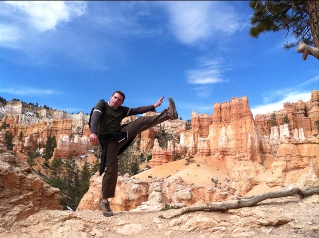
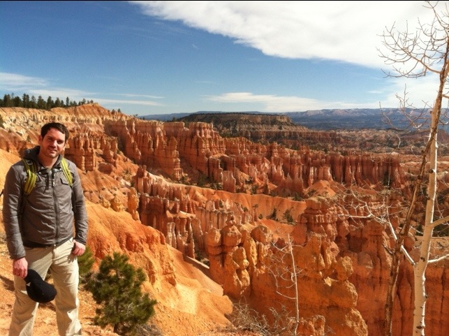
Peekaboo Loop Trail, Bryce Canyon National Park - April 2012
Our favorites:
Do: Figure-Eight Trail (6 miles – a combination of Navajo, Peekaboo and Queen’s Garden trails). A great way to explore and see Bryce Amphitheater from all angles.
Do: Bristlecone Loop Trail – easy mile-long trail at Rainbow Point with great views of the valley.
After the uncomprehensible scale of everything at the Grand Canyon, Bryce Canyon offers a nice change. Hoodoos are the tall, skinny rock formations that make the park famous. They stand below the edge of the canyon from end to end. Unlike the Grand Canyon formations, you can view a hoodoo from a distance and wrap your head around how big it is. There’s a more human scale to things. The colors of the hoodoos are amazing, and they change with the amount and angle of sunlight throughout the day. Apparently sunrise is spectacular, but we don’t do mornings that early. The park roads stay open at night, so you can even drive in and catch a glimpse under the moonlight. We were lucky enough to be there three days before the full moon. Around 10:30p.m. we headed into the park to check it out under the moon. It was beautiful, silent and quite eerie. The next morning, we hiked a 6-mile figure 8 route that took us below from the rim, twisting through the forest of hoodoos, to the bottom of the canyon and back up. We then drove the full length of the park stopping at many more viewpoints along the way. There’s not an unattractive view to be found in Bryce Canyon.
The park is in a fairly remote area, meaning there were far fewer visitors than at other parks. It was great to not have crowds of people to deal with, but it also means there are not many options for dining or other services. Although we stayed just outside the park in a small cluster of hotels, there is a great lodge and cabins within the park boundary where I would strongly consider staying on a future visit. High kick to come.

You must be logged in to post a comment.