

New Mexico’s landscapes are some of the wildest in the West, earning it the nickname “Land of Enchantment.” Driving from Carlsbad to Alamogordo provided plenty of varied scenery. The southeastern part of the state is mostly desert plains, but driving westward on Highway 82 leads into the green Lincoln National Forest and the Sacramento Mountains. At the town of Cloudcroft, the road reaches an elevation of 8,650 feet, only to plummet more than 4,300 feet in the next 16 miles. This drop marks the entrance to the Tularosa Basin, a depression enclosed by the Sacramento and San Andreas mountain ranges. This is the location of the surreal landscape of White Sands National Monument, a 275 square mile field of bright white sand dunes. Most sand is made of quartz, but unique conditions here created the world’s largest gypsum dune field. Because the Tularosa Basin is a closed system, meaning no water drains out, water-soluble gypsum gets trapped inside the basin instead of being washed to sea like everywhere else. Large selenite crystals form where pools of water dry up and eventually disintegrate into sand particles. Interestingly, because gypsum easily holds moisture and isn’t a good conductor of heat, the sand remains cool even in the blazing desert sun. Also interestingly, and somewhat unfortunately, the monument is located entirely within the White Sands Missile Range, where rockets are tested. There is a delicate balance of use between the National Park Service and the military. Sometimes the monument and nearby highway must close for a couple of hours during testing and hikers have been known to find bits of metal projectiles that landed in the sand.
The town of Alamogordo is a perfect base for exploring the monument, located just 15 miles from the entrance. We always love a nice “mom and pop” motel, so we booked a night at the White Sands Motel, right on the main drag of South White Sands Boulevard. The rooms were quiet and comfortable and the complimentary breakfast was above average. They even have a box of sand sleds for guests to borrow to take to the monument.
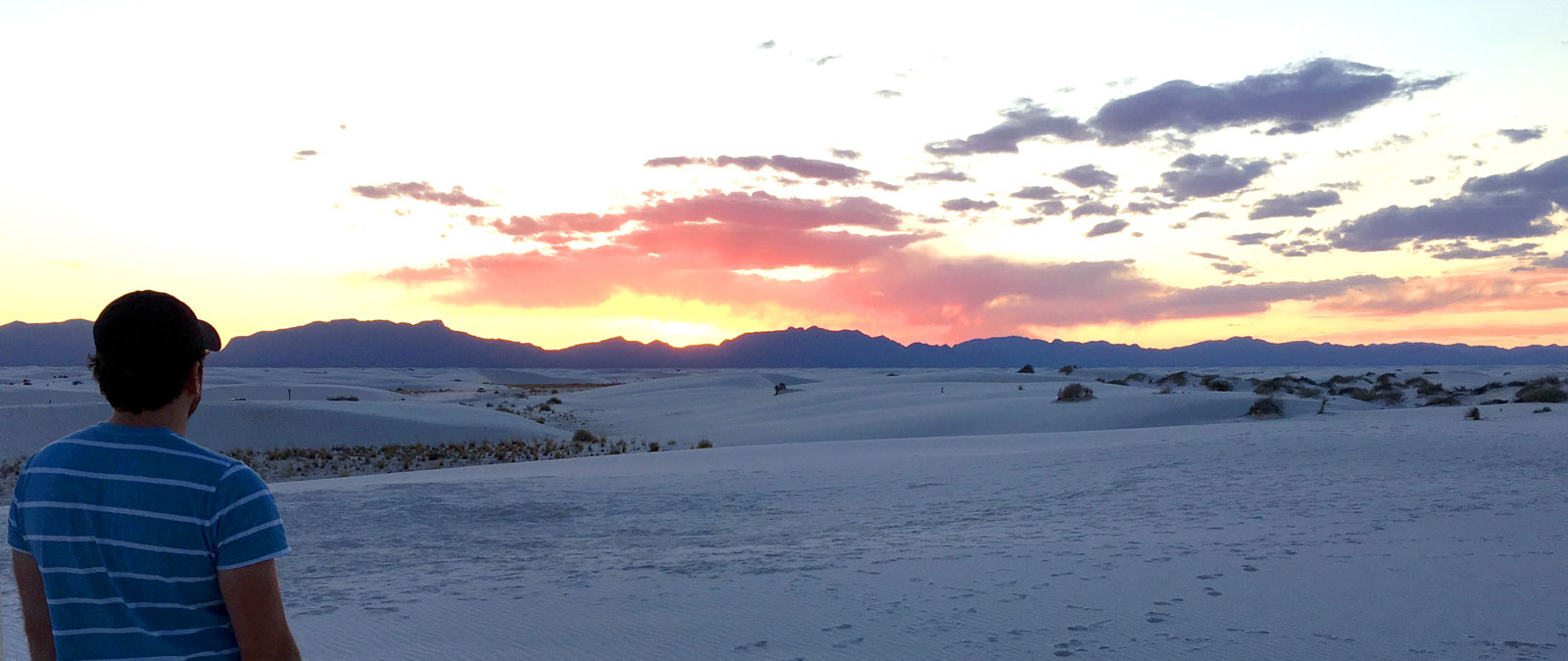
Watching the sun go down over the dunes.
Driving Dunes Drive takes visitors into another world. At first there is some vegetation in and around the dunes, but soon the road heads directly into the field, so every direction you look, all that is visible is a sea of white mounds. Even the road is white, resembling a winter scene more than a New Mexican desert. We arrived in time to join the nightly 6:30 ranger-led Sunset Stroll. No reservations are required for this walk, just find the group at the signed meeting point at about mile 5. Ranger Marie led us on a mile-long walk across the dunes, explaining the geology, history and life of the monument. It was a great introduction to the region and helped us understand what we were looking at. Toward the end of the walk the actual sunset occurs, filling the sky with pinks and purples and making the white sand transition to golden, pink and finally cool blue. The low angle of the sun on the rippling dunes makes for great photography opportunities at this hour as well. Returning to town, we found dinner at the Hi-D-Ho Drive In, an authentic alternative to the sea of chain restaurants lining White Sands Boulevard. It’s an old-school drive-in with car hop service and unique burger flavors, but sadly there were more people at the glaring Sonic drive-in a few doors down. Support the locally-owned restaurants, travelers.
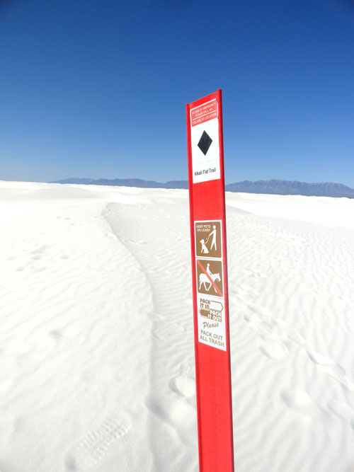
Marker along Alkali Flat Trail.
The following morning we headed back to White Sands for a more lengthy visit. We stopped by the visitor center to watch the park video and fill our water bottles. This is the only place in the monument to fill up with water, which is extremely important in such a dry place. The temperatures in April are pleasant, but the dry air will suck all the moisture out of you unless you stay properly hydrated. We took Dunes Drive all the way to the end of the road where it makes a loop through several picnic areas and a parking area for the Alkali Flat Trail. This five-mile loop through the dunes is one of the more unique hike settings we’ve experienced. First of all, there’s no well-worn trail to follow. Since the dunes continually blow and shift, footprints and pathways can get covered up almost immediately after a hiker passes. The route is marked by a series of stakes placed in the sand. It’s kind of like playing connect the dots, just walk to the next visible stake to stay on the trail. It’s very important to stay within site of the markers because looking in any direction results in roughly the same view, which can be disorienting. The trail doesn’t have serious elevation gain overall, but the dunes can be up to 50 feet high, so there are lots of ups and downs. Near the halfway point, the trail flattens out as it reaches the edge of Alkali Flat, a former lake bed that contains the crystal form of gypsum (selenite). A military complex is visible in the distance, but otherwise the only reference points are the stakes that lead back to the parking lot and the far-away mountain ranges. Back at the car, we attempted sand sledding with the plastic saucers we borrowed from the motel. It was moderately successful, especially compared with our sand boarding experience at Great Sand Dunes last summer, but we never achieved much speed or grace, and instead decided it was lunch time. We found great sandwiches at the Brown Bag Deli while passing through Alamogordo toward points northward.

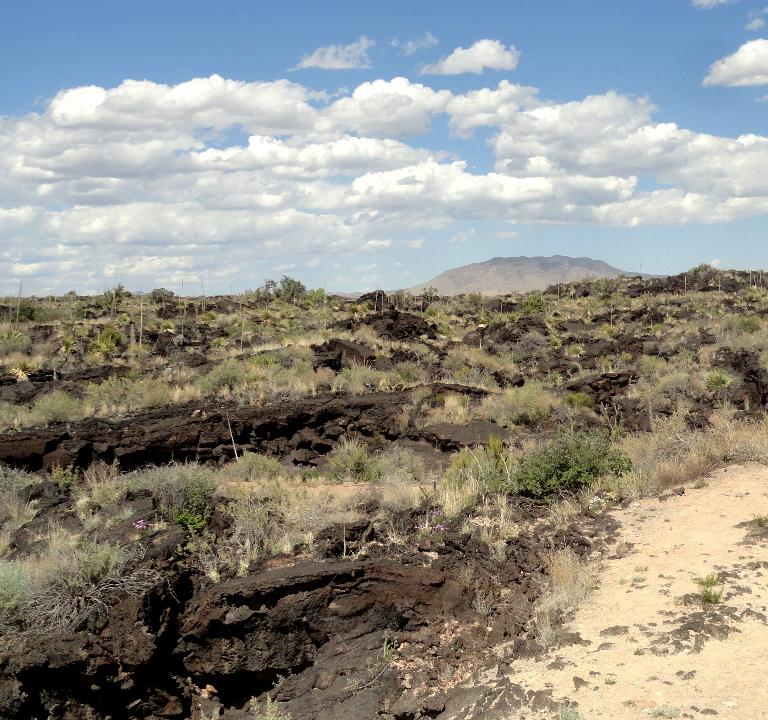
A variety of desert plants have colonized the black volcanic rock at Valley of Fires.
Sometimes just checking out an atlas is a great way to discover little detours while on the road. That was the case with Valley of Fires National Recreation Area. A little red dot on the map alerted us to its existence just off our path toward Santa Fe near the town of Carrizozo. The black, volcanic ground here was a stark contrast to the white sands we’d walked on earlier in the day. It was formed by lava that spilled out of Little Black Peak about 5,000 years ago, making it one of the most recent lava flows in the country. It covers 125 square miles and is 45 miles long but only a few miles wide. The recreation area consists of a small visitors center, a campground, picnic shelters and a short nature trail. Pick up an interpretive brochure at the center for explanations of the sights along the paved walk. Life has adapted to living in this unique environment, colonizing what from a distance seems like barren rock with a variety of desert plants and animals. After stretching our legs it was time to find the way to Santa Fe.
New Mexico’s capital city of Santa Fe holds the distinction of having many “firsts” and “oldests” in the United States and North America, but it was the last stop on this trip. Having been founded around 1610, it is considered the second oldest town in the country and its oldest capital city. It claims the oldest public building (Palace of the Governors), the oldest house and oldest church. Its age means there are many layers to its history, from Pueblo village to Spanish settlement, all the way to its emergence as a major art center and ultimately its 2005 designation as a UNESCO Creative City. At 7,200 feet in elevation, it’s also the highest state capital, but at 70,000 residents it’s modestly sized and approachable. Santa Fe lies in a bowl with the Sangre de Christo Mountains to the east and the Pajarito Plateau to the west. The downtown area was laid out in the early 1600s according to the “Laws of the Indies” that the Spanish used as guiding principles in urban design. A grid of streets radiates out from a central plaza surrounded by adobe buildings  and arcades. In the early 20th century, with a variety of architectural styles encroaching on the historic adobe look of Santa Fe, the city decided to protect its unique look by requiring all new and rebuilt buildings to adhere to the “Pueblo Revival” style. Today the city’s look is still intact. It works especially well in the historic center around the plaza, feeling authentic and unified. Outside of downtown it seems like overkill to have adobe-style fast food restaurants and tire shops, but overall it’s an attractive settlement by any standards.
Our lodging for two nights was El Rey Inn, located southwest of downtown on the major thoroughfare of Cerrillos Road. It’s a beautiful property with nicely decorated rooms and landscaped courtyards between the various buildings. The hot tub was great for our legs after a week during which we hiked more than 40 miles. In the food department we loved the Mexican platters and margaritas at La Plazuela restaurant inside La Fonda hotel. The hotel/restaurant is one of the famous properties that was operated by the Fred Harvey Company from the 1920s through the ‘60s. The restaurant occupies a skylight-covered courtyard in the center of the building with ornamental trees and ornate tile work, a lovely setting for lunch. Our other meals were more casual affairs enjoyed with our Santa Fe friends and their kids. The Cowgirl Restaurant is great for families with children and has a great beer list for the adults as well. We also loved the atmosphere at Draft Station/Rooftop Pizzeria directly overlooking Santa Fe Plaza. They have a good local beer selection, unique pizza styles and a large game room that means fun for all ages. Our favorite morning coffee/breakfast spots were Iconik Coffee Roasters tucked away on Lena Street and Tune-Up Cafe on Hickox Street.
Probably the best known reason to visit Santa Fe is for its art scene. It has long been a center for native crafts and folk art. Georgia O’Keefe settled near here and fell in love with the New Mexican landscape. Today there is a high concentration of artists practicing all varieties of art. Galleries are visible all over town, especially along Canyon Road. Even the state capitol building’s circular corridors are lined with works created by New Mexican artists.
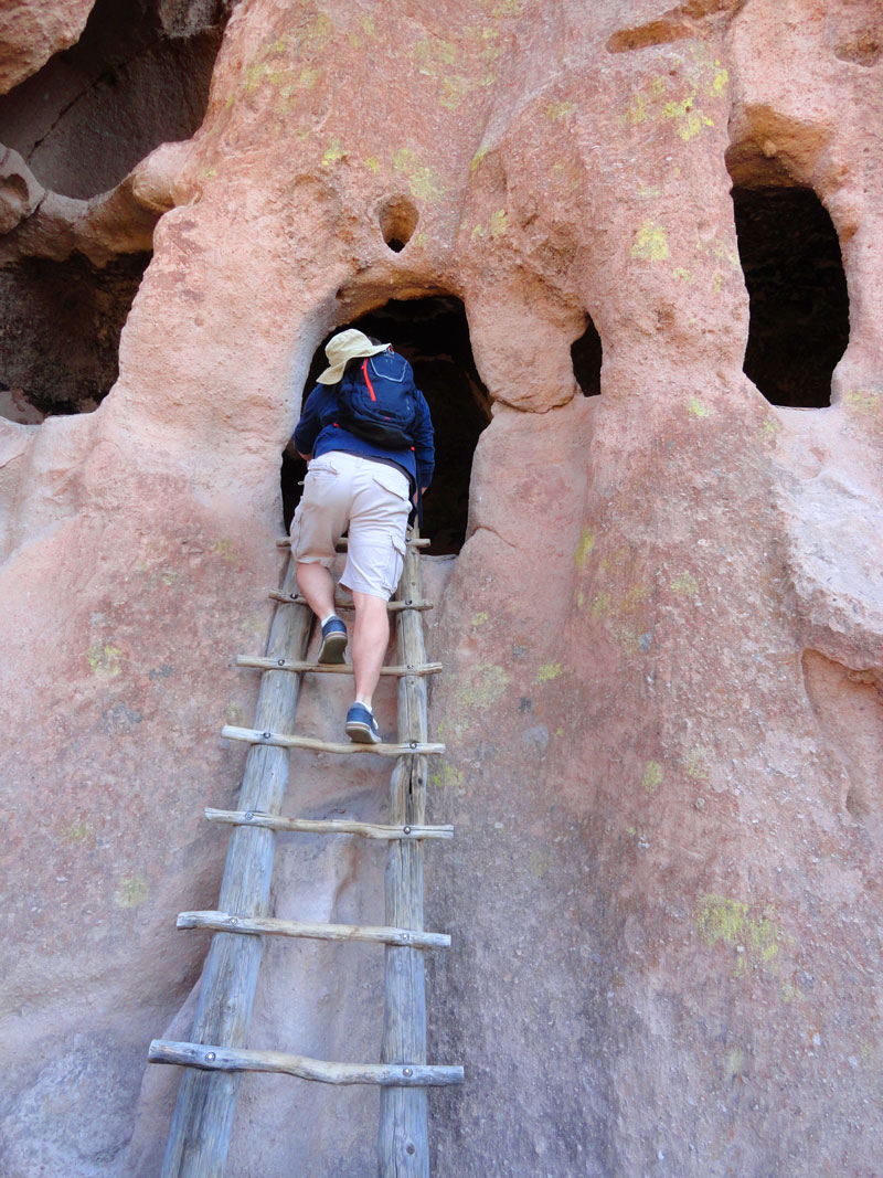 Outdoor recreation has a huge influence on tourism as well, with hiking, biking and skiing all available nearby. We took a day trip to Bandelier National Monument to add to our hiking miles. Located a scenic hour drive from Santa Fe near the town of Los Alamos, Bandelier is the oldest of the National Park Service sites we visited on this trip, established in 1916. The monument preserves the homes and territory of the Ancestral Puebloan cultures, whose descendants still call New Mexico home. The monument covers 33,677 acres, but the majority of the amenities are contained within Frijoles Canyon. This is where the main park road leads to an impressive collection of rustic-style Civilian Conservation Corps era buildings, a.k.a. “Parkitecture”. The visitor center has a thorough interpretive museum explaining the lives of the people who lived in Frijoles Canyon. It is believed they were groups that moved south into New Mexico after leaving the area of Mesa Verde National Park in present-day Colorado. The 1.2 mile Main Loop Trail begins here and takes visitors past a range of dwelling styles, rock paintings and petroglyphs. Tyuonyi Pueblo comes first, which is a large, circular, multi-room structure that likely once stood up to three stories high. Nearby, the site of Long House displays neat rows of holes carved into a sheer cliff that once supported floor beams. Residents also carved extra back rooms out of the soft volcanic ash rock. Further along the trail, Alcove House can be reached by climbing 140 feet of ladders. Sheltered by an overhang of rock, it’s reminiscent of the cliff dwellings we toured at Mesa Verde last summer. Bandelier contains 70 miles of hiking trails in total, mostly backcountry routes, but only three miles of road, so there’s plenty more to explore on a longer visit.

Tyuonyi Pueblo viewed from the trail to Long House.
Before heading home, we had one more must-see Santa Fe site to see. An arts collective called Meow Wolf has transformed a former bowling alley into the interactive experience “The House of Eternal Return.” Inside, they have created a world that tells the mysterious story of a family and their home that guests can begin to unravel through exploration. Room after room contains wild scenes that bend space and time and provide clues as to just what happened here. It’s one of those experiences that blew away our expectations. We spent a couple hours inside, but could have stayed in much longer, untangling more of the mystery, but we had a train to catch, and that’s a whole other story.
Up next: Amtrak Southwest Chief
Previously: Marfa, Guadalupe Mountains, Carlsbad Caverns
Previously: Big Bend National Park

You must be logged in to post a comment.