
During our three week vacation in June/July we hiked a grand total of 102.5 miles, 33.9 of which were in Yosemite National Park. This park contains an incredible 800 miles of trails, so we’re just scratching the surface here, but we still covered quite a bit of ground and elevation. There are practically limitless options for future visits. Here is a description of the best of this summer’s Yosemite hikes:
Hetch Hetchy:

We began our Yosemite visit in the Hetch Hetchy Valley. Near the Big Oak Flat entrance on California Highway 120, Evergreen Road winds 14 miles to the Hetch Hetchy Backpackers Camp via the Mather Ranger Station entrance. The valley and the controversial Reservoir it contains come into view as the road descends the side of a steep mountain. Despite John Muir’s calls for preservation, the valley was flooded by the O’Shaughnessy Dam in 1923 to provide power and water to the growing San Francisco Bay Area.

Wapama Falls from the bridges.
Today the dam serves as the trailhead for routes along the lake and backcountry points to the north and east. The most popular hike in the area is a 5.5 mile out-and-back to Wapama Falls along the Hetch Hetchy Reservoir Trail. We selected this option because we were arriving in mid-afternoon (after driving from San Francisco) and it only takes a few hours to complete. If time allows, a 13-mile hike can be made by continuing along the same trail to Rancheria Falls. Wapama Falls is visible across the reservoir from the trailhead and the dam, giving a nice reference point for your final destination. The trail actually crosses the top of O’Shaughnessy Dam and then goes directly into a 500-foot tunnel. The next mile of trail is a wide, mostly level former construction road. After the junction with the Miguel Meadow Fire Road that heads into the backcountry, the Hetch Hetchy Reservoir Trail narrows to a more typical width and gets a bit rockier. There are a few minor ups and downs, but it’s an easy hike with continuous views of the reservoir and Kolana Rock towering on the other side. There is a seasonal waterfall along the route called Tueeulala Falls, but it was already dry during out late June visit. Wapama Falls itself is not visible from most of the trail, but rounding a slight curve just before it creates a grand reveal of the lower portions of the 1,100 foot drop. A series of footbridges cross the cascades and rock rubble at the base, giving close up views through the mist. We returned on the same route and arrived back at the trailhead about 2.5 hours after we departed. Overall it was a good warmup for the much more strenuous hikes we had planned in the near future. That night we had a site with our names on it at the Hodgdon Meadow Campground back near the Big Oak Flat Entrance.
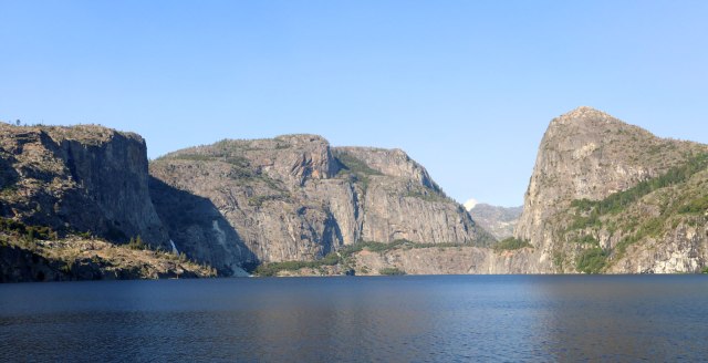
Hetch Hetchy Reservoir viewed from O’Shaughnessy Dam. Wapama Falls is visible in the shadow left of center.
The Valley:
Yosemite Falls Trail
“This trail is a bitch,” we said after what felt like the 1,000th switchback of the Yosemite Falls Trail. At 7.2 miles round trip and 2,700 feet of elevation gain, we weren’t expecting it to be easy, but we’ve hiked those distances and heights many times before without feeling so exhausted.
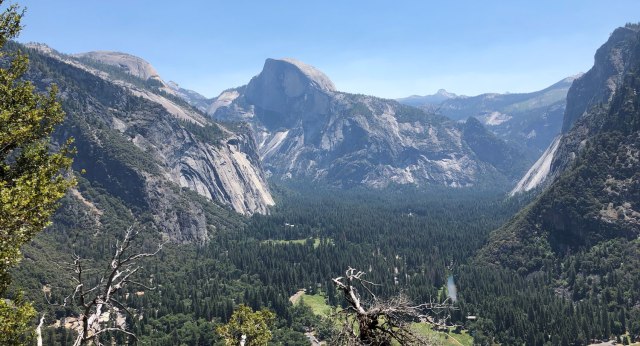
Looking toward Half Dome from Columbia Rock, just over a mile into the hike.
On our first full day in Yosemite Valley (staying in the rustic tent cabins at Half Dome Village), we decided to hike to the top of one of the most famous sights in all of Yosemite National Park, Yosemite Falls. This is usually considered the tallest waterfall in North America. It has a total drop of 2,425 feet, consisting of an initial 1,430 foot plunge, 675 feet of cascades and one last 320 foot drop. We stocked up on lunch and snacks in the main village store before taking the shuttle to Camp 4 and the Yosemite Falls Trailhead. From the beginning, this trail has a pretty constant and steep vertical rise. Countless quick switchbacks weave through a shady oak forest for about the first mile. After that it takes a more direct route traversing the north wall of the valley with views of the meadows and forests below. Columbia Rock provides a good resting point with views that extend from Half Dome in the east to Cathedral Rocks to the southwest.

Upper Falls reveal.
About a mile and a half in, the first view of Upper Yosemite Falls is revealed. It’s a stunning sight with ribbons of water alternately floating and crashing down the sheer rock face. Up to this point, the trail has a fair amount of hikers, but many turn back after the viewpoint and it got a little more secluded from here on. After climbing relatively gently for a while, the route doubles back away from the falls and begins a zigzagging ascent that feels like it will never end. At this point there are also no shade trees, leaving us in the full heat of the midday sun while climbing a very steep incline. This is the portion where we decided this hike was a bitch. I checked the trail map on the AllTrails app and counted nine switchbacks before the summit. We began counting down the turns before we’d reach the intended picnic spot. Finally we crested a ridge and had a gentle walk down to the brink of the upper falls. The best plan here is to find a slightly shady spot on the rock for lunch. We refueled and then explored the steep staircase that leads to a ledge with a direct view of the river tumbling over the edge.

Overlooking the brink
The route back down is the same, but fortunately for us the advancing afternoon sun was hidden behind the cliffs for most of the way. Total hiking time was about 5.5 hours start to finish. At the Yosemite Valley Lodge, we chugged sodas before catching a shuttle back to our tent cabin. This is where the novelty of the shuttle system wears off. We were disgusting and exhausted from our long day and then had to wait for a bus with enough room.
In the aftermath we were starting to wonder if we’d lost some of our hiking mojo, but after talking with other experienced hikers who had taken the same trail, we confirmed that it’s not just us, this trail is in fact, evil. But it’s definitely rewarding in return.
Mirror Lake:
The day after our Yosemite Falls hike we decided it was best to stay at lower elevations in the valley to give our legs a chance to recover. Heading toward Mirror Lake seemed like the perfect option. This popular destination sits toward the head of the valley directly under Half Dome. A small, seasonal pool in Tenaya Creek reflects the surrounding rock faces in its calm surface. From the trailhead at shuttle stop #17 there are two options for reaching Mirror Lake. The most direct route is a 2 mile round trip walk up the paved Mirror Lake Trail, but the more interesting route is a 5 mile loop accessed by veering onto the unpaved trail before the first bridge.
 We circled the loop in a counter clockwise direction, first walking through the woods on the south side of the canyon. Less than a mile in, we encountered a bobcat sitting in the center of the trail. An oblivious, coffee-carrying couple coming the other direction didn’t see it until they were almost in front of it. The cat calmly left the trail, but lurked alongside us in the trees for about five minutes as we continued on our way, allowing me to get several good photos. Soon after, we reached the shore of Mirror Lake, which in late June was already shrinking from its peak size due to dwindling runoff. The surface was still large enough to offer some impressive reflections, but by late summer they say it’s usually more meadow than lake. Up to this point there had been a few other hikers on the trail, but few go beyond Mirror Lake, so we had a good portion of the loop all to ourselves. The trail continues a little more than a mile on the south side of the canyon before crossing a picturesque bridge and turning back toward Mirror Lake on the north side. The woodsy area back here was buggy, but otherwise pleasant. On the return trip, we saw the more heavily visited side of the lake, where there are interpretive signs on the area’s geology and early 20th century tourist visitation. The way back to the trailhead and shuttle stop is on the previously mentioned paved walkway. With only a couple hundred feet of total climbing, this easy trail was perfect for our “day off” and is also great for families or anyone not willing or able to scale 3,000 feet of canyon wall.
We also spent the rest of the day with lower-elevation activities, like an architectural tour of the historic Ahwahnee Lodge (Majestic Yosemite) and a visit to the base of Lower Yosemite Falls.

The appropriately-named Mirror Lake with Mount Watkins in the background.
Glacier Point via 4-Mile, Panorama, Mist:
After staying on mostly level ground for a day, we were again prepared to tackle the full height of Yosemite Valley. This time we’d be ascending the south face, making our way to the Glacier Point overlook, 3,200 feet above. The most direct route to Glacier Point is by hiking up the Four Mile Trail. We rode the shuttle from Half Dome Village to Camp 4 and then walked across the “Swinging Bridge” to reach the Four Mile Trailhead along Southside Drive.

Ascending the shady Four Mile Trail.
This trail is nearly as steep as the Yosemite Falls Trail directly across the valley, but seems less demanding. It’s probably because in the morning it is mostly shady and doesn’t contain nearly the number of monotonous switchbacks. It does its fair share of winding back and forth, but each turn seems to offer a new view of the surrounding landscapes. El Capitan and Cathedral Rocks rise prominently to the West during the early miles and the entirety of Yosemite Falls is nearly always visible on the opposite side of the valley. About 3.5 miles up, Union Point offers a nice lookout spot to take in the view and rest a bit before ascending one more set of switchbacks and then following a relatively level trail to the overlook at Glacier Point.
Since Glacier point is also accessible by road, there are suddenly throngs of people milling around. It’s a bit of a buzzkill to be surrounded by the car-dependent masses after putting in the hiking effort, but as an upside there’s a snack bar up there, so we didn’t have to carry up our lunch. We grabbed sandwiches and found a semi-secluded rock to lounge on. The presence of so many people makes for bold woodland creatures. A ground squirrel circled the area several times, and during a moment of distraction stole the top bun off Nick’s sandwich. It’s proof that sometimes the most memorable moments are not what you’d expect.
After lunch, we went to the Glacier Point overlook to take in the view. This is one of the most expansive views in the park, with nearly all of the upper Yosemite Valley visible. Our tent cabin village was directly below us, with earlier destinations like Yosemite Falls, Mirror Lake and the Ahwanee Lodge all visible. From this vantage point, Half Dome is straight ahead and looks stunning. To the right, we also got our first view of Nevada Falls and Vernal Falls, future destinations on this hike.

View of Half Dome, Nevada Falls and Vernal Falls from Panorama Trail just below Glacier Point.
From Glacier Point we made the first part of our return trip to the valley on the Panorama Trail. The first 2.4 mile section of this trail makes a single, gradually descending traverse across a grassy hillside toward Illilouette Falls. This 370 ft waterfall is mostly obscured from view except for one overlook just off the trail. After crossing Illilouette Creek just above the brink, the trail begins a long climb back up 800 vertical feet over the next 1.5 miles. Yosemite Falls returns to view, this time off to the distant west, reminding us how far we had hiked since the morning. At mile 9.5, Panorama Trail levels off and then begins a descent to Nevada Falls, where the Merced River plunges 700 feet down a rock face. An overlook adjacent to the Nevada Falls brink gives a dramatic view of the dizzying height. We took a snack break here along with several other hikers. A few major trails converge in the area, including the routes to Half Dome, Clouds Rest and the High Sierras to the east, so after seeing only a handful of people since Glacier Point, we were back in more trafficked territory.

Going down the rocky steps next to Nevada Falls.
Just beyond the falls, we took a left onto the Mist Trail and descended a section so steep it is carved into a set of rocky switchbacking steps. Knee abuse aside, this section is fun to climb down, with the roaring falls just off to the side. Further along through some forest the gorgeous Silver apron and Emerald Pool provides a brief pause for the water before it careens off the edge of the last waterfall of this hike, Vernal Falls. At 317 feet it is short compared to Nevada, but in the fairly heavy flow of early summer it creates a near perfect curtain of water. Below this point is where the Mist Trail really earns its name, with a continual rain of tiny droplets swirling through the valley. The more than 600 granite stairs are slippery and all the vegetation is a well-watered bright green. The Mist Trail soon merges into the

Vernal Falls viewed from the Mist Trail
John Muir Trail which becomes a smooth, paved downhill to the valley floor. From the trailhead we were just a short 0.4 mile walk from our tent cabin and a much needed shower.
In total this route was 14.4 miles with a total climb of 4,564 feet, which puts it among our longest day hikes of all time. We highly recommend it because it hits some popular sights but also offers long stretches of seclusion with breathtaking views the entire time.
Mariposa Grove:
On our way out of Yosemite’s South Entrance, we stopped by Mariposa Grove of Giant Sequoias for a quick hike. The area was recently reopened after a three-year restoration to make visitation more environmentally sensitive. Guests no longer drive right into the big trees, but park at a new visitor center and then board shuttle buses that make the 5-minute ride to the edge of the grove. This was our first experience with Giant Sequoias of the trip, we’d later see many more (and larger) trees at Kings Canyon and Sequoia National Parks, but this was a good introduction to the habitat.

The Grizzly Giant
There are several linked trails hikers can make through Mariposa Grove, ranging from a half mile to seven miles. We chose a medium length route of 2.3 miles on the Grizzly Giant Loop Trail. The early parts of the trail are accessible boardwalks, and the route up to the Grizzly Giant is only slightly inclined and well-worn. On the way there are several examples of mature sequoias towering overhead. The Grizzly Giant at the far end of the loop stands 209 feet tall and is the 25th largest living tree in the world by volume. Teddy Roosevelt and John Muir famously camped in its shadow during their 1903 Yosemite excursion. The nearby California Tunnel Tree was hollowed out in 1895 to allow a horse and carriage to drive through. Not very environmentally sensitive, but it makes for a cool photo op these days. Completing the Grizzly Giant Loop Trail doesn’t lead to a whole lot of other sequoias, but it is gently sloped and a pleasant walk back to the shuttle stop.

You must be logged in to post a comment.