
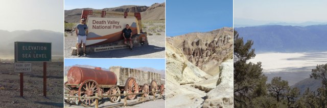
In the rugged Mojave desert 120 miles west of Las Vegas lies the famed Death Valley. At 5,270 square miles, it is the largest national park outside of Alaska and ranks fifth overall. Long on our radar, we decided to work it into this itinerary because it fits better seasonally and geographically with Arizona than the big cluster of California parks. Its size can be a challenge for planning. For example, it takes more than two hours to drive from Ubehebe Crater in the park’s northern reaches to the Ashford Mill Ruins at the southern end. There are also several sites, like the famous moving rocks of The Racetrack, that are inaccessible without a high-clearance four wheel drive vehicle. With awareness of these factors, plus some good research, it’s pretty easy to come up with a plan to hit a lot of choice spots. Most people are surprised to find more variety of landforms than expected. In addition to containing the lowest place in North America, it is home to multiple mountain ranges, pushing as high as 11,000 feet. There is cultural history here as well. The Timbisha Shoshone Tribe’s ancestral lands are within the park boundaries and they are still an active part of the community. Their ancestors followed a seasonal migration pattern based on elevation to live in balance with the seasons, summers in the high mountains and winters on the valley bottom.

Zabriskie Point landscape and hat-stealing winds.
We arrived on a Thursday afternoon after a 6.5 hour drive from the South Rim of the Grand Canyon. Entering from the east on California Highway 190, we headed directly to the Furnace Creek visitor center to orient ourselves and catch the last daily showing of the park movie. A large thermometer outside the entrance read 89 degrees, but highs here in the summer commonly reach 120 degrees and above. A weather station at Furnace Creek still holds the record for highest observed temperature on Earth of 134 degrees, set in 1913. Autumn through spring is obviously the main visitation season as a result, with some lodging and amenities closing up shop for the fiery summer months. In addition to heat, a dust storm greeted us as we entered the valley, with brown clouds rolling across the valley floor carried by intense and constant winds. From the visitor center, we backtracked a few miles to Zabriskie Point, where a short path leads to a viewpoint overlooking dramatically weathered badlands. The wind here was so strong that standing upright became an isometric exercise. We held onto hats and skirts and took in the view. Another place to experience this landscape is the nearby 20 Mule Team Road, a twisting gravel drive that threads between the mounds. The name 20 Mule Team references the teams of mules and horses that were used to carry borax from mines to processing plants in the 1880s. Remnants of this industry can be seen in the Harmony Borax Works, our next detour. It has a short trail that loops around the ruins of an old borax processing facility and informational signs on how the process was carried out. One of the old mule team wagons is on display here as well. Industrial use of such a harsh environment seems surprising to us now, but there was a time in the late 19th and early 20th centuries when Death Valley was of major interest for its natural resources, and industrial ruins and ghost town sites dot the park as a result.
Continuing 25 miles north, we arrived at our lodging at Stovepipe Wells Village. With its on-site restaurant, general store and swimming pool, we found it an ideal combination of location and amenities for a reasonable price. The hotel dates to 1925, when the region began its transition from mining to a tourism economy. Perpetual dust and an hourglass shower timer reminded us we weren’t in the average neighborhood. The Toll Road Restaurant satisfied for breakfast and dinner, importantly staying open until 9:00pm, so we weren’t rushed with our dining schedule like we sometimes are in remote areas. One disappointment was the non-functioning bar tap system that weekend, denying us the pleasure of a well-curated beer list.

Charcoal Kilns at the Wildrose Peak Trailhead.
Our longest hike of the whole trip was planned for Friday, April 14th. Surveying the day hike options via Death Valley’s NPS website and in our National Geographic book, we settled on Wildrose Peak as the ideal trek. With a summit at just over 9,000 feet, it stands 2,000 feet lower than the park’s highest mountain, nearby Telescope Peak, while still offering commanding views. The trail’s round-trip distance of 8.4 miles and climb of 2,300 feet allows a more leisurely pace than the 14-mile route up and down Telescope. From Stovepipe Wells, a nearly 1.5 hour drive up squiggly Emigrant Canyon Road leads to the trailhead adjacent to 10 historic charcoal kilns. Another remnant of the industrial days, these 25-foot-tall beehive-shaped stone constructions were used to create charcoal from local wood to be used as fuel in smelters at nearby mines. Wildrose Peak Trail begins here by entering green forests of pinyon pine and juniper. The temperatures at this elevation (6,800 at the trailhead) made for pleasant hiking. Just less than two miles in, we reached a saddle in the mountains and were rewarded with our first view into Death Valley below. After a brief level portion, the trail steadily increases in angle before becoming a series of switchbacks on a steep slope toward the top. Just before the true summit is a false peak, and the last quarter mile is a mostly level walk to the tip top. Wildrose Peak provides nearly 360 degree views of a vast surrounding area. Mt. Whitney, the highest point in the Lower 48, is visible in the Sierras on the western horizon, and Badwater Basin lies below sea level just 15 miles to the east. The Panamint Range stretches to the immediate south, with snow-dusted Telescope Peak poking up from behind Rogers Peak. We ate our picnic lunches downwind of the summit to shelter ourselves from the chilly breezes, a major change from the hot valleys below. A few other hikers arrived, but for the most part, the trail was nearly private. After about an hour, we turned and made our way back down the way we had come up. In total, the hike was just under six hours, a perfect day hike length.
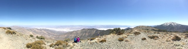
Panoramic view from Wildrose Peak. (click for larger view)
Back at Stovepipe Wells, we sourced six packs from the general store across the street and relaxed on the shaded patio. Just before sunset, a trip to the nearby Mesquite Flat Sand Dunes gave us the perfect vantage point for the beginning of twilight. In this area, dunes up to 100 feet high stretch in every direction. There are no official trails, but visitors can wander up and down the sand as they please. Back at the hotel, we downed mass amounts of food and then returned to the patio with a bottle of wine to enjoy the firepit and clear, starry skies of this International Dark Sky designated park.
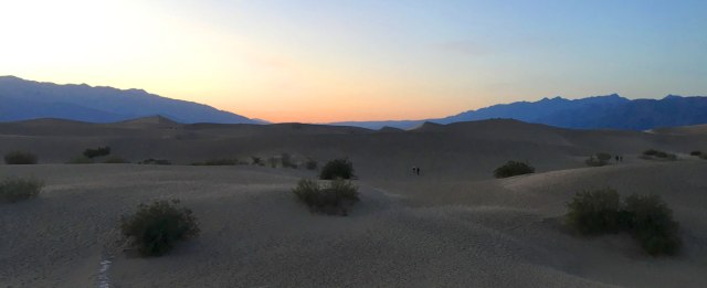
Sunset from the middle of the Mesquite Flat Sand Dunes.

Salt Creek Pupfish.
The final full day of our road trip consisted of lots of stops on our way from Stovepipe Wells to the park exit in the general direction of Las Vegas. First on the route was the Salt Creek Interpretive Trail, a boardwalk meandering along a marshy, spring-fed creek. This hot, salty water is home to the endangered Salt Creek Pupfish that eke out a life in tiny, isolated streams and pools whose conditions would kill most other aquatic animals. They get their name from the playful way they interact with each other, which also makes them surprisingly entertaining to watch for little 1.5-inch-long fish. Next up, we passed by Furnace Creek and went to Golden Canyon, where a network of trails passes through yellow hills and narrow gorges. Options range from easy strolls up to an 8-mile fairly strenuous loop. The routes even connect to Zabriskie Point on the eastern side. We chose a middle ground by hiking up Golden Canyon as far as the Red Cathedral. With a round-trip length of three miles and an elevation gain of nearly 600 feet, it was more strenuous than expected, with the 85 degree heat amplified by the rock walls all around. At Red Cathedral the trail dead ends into a vertical rock alcove, where climbing a small rise affords views out over the valley and to the Panamint Range beyond.

The salt flat at Badwater Basin.
Fifteen miles south, we arrived at the quintessential Death Valley location, Badwater Basin. At 282 feet below sea level it is the lowest spot in North America. A sign marks sea level on a cliff high above. Just off the parking lot, a boardwalk gives way to a well-trodden path out into the salt flat. The surreal, white landscape all around is formed when water collected in the basin evaporates and leaves a layer of salty minerals behind, building into a thick crust over time. We walked out far enough to get a good vantage point of the valley around. The heat felt intense, even sub 90 degrees, making us cringe at the thought of being here in the summer. Off to the west, we spotted Wildrose Peak, where 24 hours earlier we’d stood looking down at Badwater Basin. From the hot valley floor we could see three patches of lingering snow on Wildrose, highlighting the wild range of conditions within the park. Approaching a late lunch time time we turned northward toward the Furnace Creek village, making a brief stop at the jagged formations of Devil’s Golf Course and detouring on Artist’s Drive through multi-colored canyon walls. After lunch, we ended the visit with a side trip to Dante’s View, located off Highway 190 where we had entered the park two days earlier. The 28-mile round-trip drive seems far, but we were glad we took the extra time because Dante’s View might be the most stunning vista in the park. At 5,475 feet in elevation, people on the Badwater Basin trail look like ants more than a vertical mile below. We stood in awe viewing nearly the entirety of the north/south stretch of Death Valley. What a way to say goodbye to an amazing national park. We covered a lot of ground, but there is plenty more to be discovered on a future visit. We’re putting this one in the must-return column.
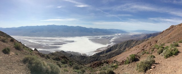
Parting shot: Panorama from Dante’s View. Badwater Basin is the white area on the valley floor and the Panamint Mountains rise in the background.
 Our flights were out of Las Vegas the following day, so we booked a room at the Main Street Station Casino Hotel downtown. We thought maybe downtown would be less trashy than the strip… it wasn’t. We’re not fans of Las Vegas in general, but it’s even more depressing after having spent a week in some of the country’s best scenery. That being said, we did find one redeeming experience with dinner at Carson Kitchen. We toasted another successful trip over tasty small plates and brainstormed future travels.
Previously: Flagstaff and Grand Canyon
Previously: Petrified Forest and Canyon de Chelly
Previously: Tucson and Saguaro National Park
View trip photo gallery here.

Pingback: Travelogue: Flagstaff and Grand Canyon | highkicktravel